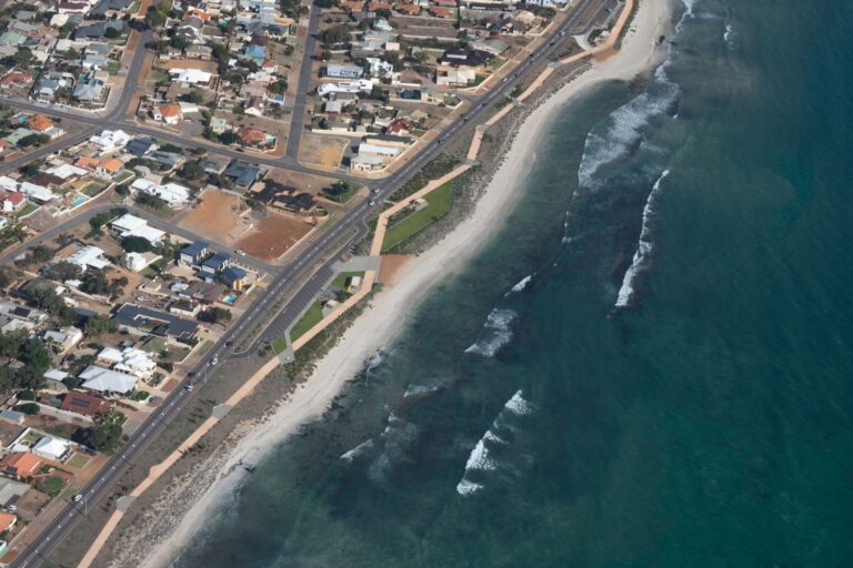
The caravan park in Mallacoota
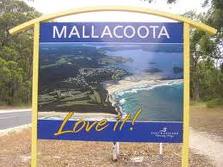
About a half hour after leaving the highway we arrived at the Shady Gully Caravan Park in Mallacoota. What a nice park! We had our pick of shady (naturally), grassed campsites and set about getting our camp organised. Thank heavens it was still daylight; that annex is just like putting up a tent and it’s not something I care to do after dark! The late afternoon was perfect and we went for a little walk around the park. It’s very well laid out, all the sites are quite large and there is plenty of grass and shade. The park also boasts its own swimming pool and is in a native bushland setting close to the beach. What more could you ask?
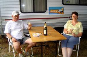
First night bubbly in Mallacoota
Back at camp we settled down for our first night ritual. We always celebrate our first night at a new caravan park or campsite with a bottle of Two Tails Sparkling Wine and tonight, after a long day on the road, I was certainly looking forward to it. It’s quiet and peaceful here; the only sound was the soft noises of insects and the surf. We made use of the camp kitchen with its free gas barbecues and after dinner went for another walk around the park before turning in for the night. The weather promises to be hot so I think I’ll be making use of that swimming pool as well as visiting the beach!
Exploring around Mallacoota
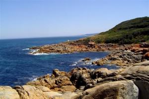
A sparkling morning greeted us the next day. The sun was shining and it promised to be a gorgeous day! After a leisurely breakfast we headed for town for a few supplies and a quick drive around the town of Mallacoota before setting off for some sight-seeing. Apart from the main road into town there are a couple of roads that lead to some secluded fishing and swimming spots. One of these is Betka Road. It runs parallel to the coast heading west and is unsealed for the most part. It is only about 15 kilometres (9 miles) long so we decided to go right to the end and work our way back. About 7 or 8 kilometres (4 or 5 miles) along the road where Betka Road became Betka Track there was a sign to Shipwreck Creek, another 8 kilometres (5 miles) further on.
Shipwreck Creek? I can understand that!
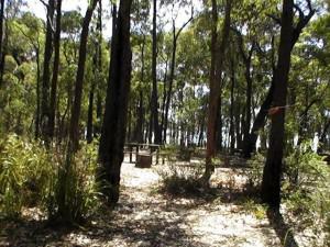
Well, 7 of those kilometres were pretty rough. John said a two-wheel-drive vehicle could do it easily with a bit of care but I don’t think I’d like to take my car along there, no wonder they call it “shipwreck”. At the end of the road is Shipwreck Camp.
There is a parking area plus a few campsites and an area for day-trippers. We parked the car and set off for a ½-kilometre walk down to a most spectacular beach. All part of the 86,000-hectare (212,500-acre) Croajingalong National Park and every time I hear that name I’m reminded of an old Slim Dusty song that my Dad used to sing: “Croajingolong, is the place where I belong, where a gum tree shade meets a sunstreaked bay and I can’t wait to go along to Croajing-aling-aling-along”. The Croajingolong is one of the few places in the world with an amazing diversity of landscapes and ecosystems that are so valuable UNESCO has declared it a World Biosphere Reserve.
A perfect beach
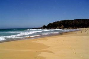
We followed the well-defined path through the trees and bush to the beach. Parts of the track were quite steep and walking down wasn’t a problem; it was the thought of having to walk back up again that made me grimace! But down on the beach it was so peaceful, there wasn’t a soul there. The water was incredibly blue and it was as close to perfect as I think you can get. The beach was reasonably well sheltered from the wind that had come up and it was certainly worth the walk. But now it was time for the return walk! It took a bit longer to get back to the top and we did arrive somewhat out of breath but John said it couldn’t have been that bad, I only complained twice!
Beaches along the Wilderness Coast
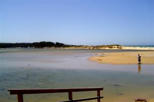
We left Shipwreck Creek and set off along the track to the next beach, Pebbly Beach. The walk down was shorter than before but the view was no less spectacular. The beach was very rocky, hence the name, and there was a lot of weed in the water. Definitely no good for fishing, I was told. Again, the beach was deserted but we weren’t the only ones to visit this morning, there were some fresh footprints in the sand. Man Friday, perhaps? Our next stop was at the Secret Beach Lookout and we found out why it’s such a secret; you can’t see the beach. The bush and trees have grown up around the viewing platform completely obscuring the view! You can just see the ocean if you climb the railing around the platform. At Quarry Beach, a little less sheltered than the others, the wind was blowing a gale! It looked like a very popular beach with families playing on the sand, people walking their dogs, but no one in the water. There were a couple of surfboards on the sand along with their very dejected-looking owners and John asked them why they weren’t in the water. ‘Stingrays, and lots of them’, was the reply. The graceful creatures have had a lot of bad press following the untimely death of the Crocodile Hunter, Steve Irwin, so we could well understand why no one wanted to brave the surf.
No good for fishing
Closer to town we discovered Betka Beach and the Betka River. There was parking and a picnic area right on the river and a short walk across ankle deep water to the beach.
Again, it was extremely windy and it didn’t look good for John’s planned fishing afternoon. There were some people in swimming and the water was quite warm but once you came out of the water the wind was cold. The river was quite shallow near the picnic area and I imagine that on a less windy day there would be a lot of children playing there but for now there was a lone fisherman standing on the bank. It didn’t look like he was catching anything much and my comment about that appearing to be normal earned me “the look” from John.
Another off-road track. Oh joy!
Back on the road and heading for town, John found a track. After previous off-road experiences with my man I knew there was no way to stop him so I tightened my seat belt and prepared to hang on for dear life! But, as it turned out, it was a very short track that led to a spot on the river with a boat ramp. A really nice spot with fish jumping in the water! I could almost see the twinkle in John’s eye!
A stretch into infinity
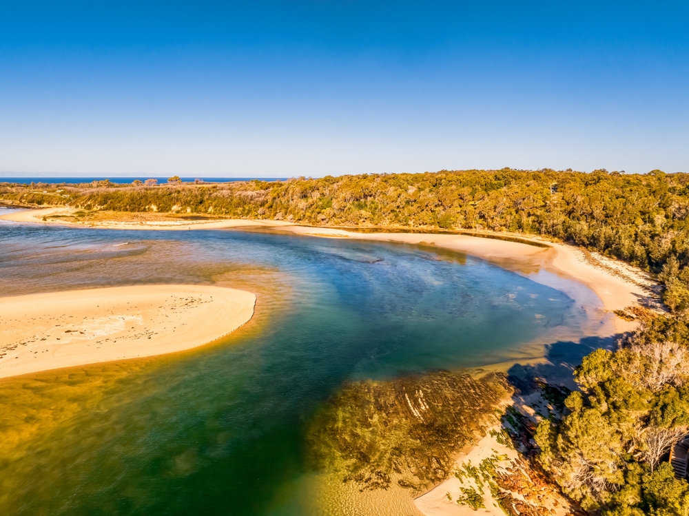
Crossing over the river on the way back, we stopped in a little parking area leading to Davis Creek Beach. This is another lovely spot for a picnic but a long walk down a bush track to the sand. At this point we decided to go back to camp for lunch. The wind was blowing even stronger now than it had been and a picnic on the beach would not have been very pleasant. There are several more beaches in this area and after lunch we explored Tip Beach. What a beautiful beach! This is what I’d always imagined Bass Strait to be like, the water was so blue and it seemed to stretch into infinity. The wind had dropped a little, too. This was more like it!
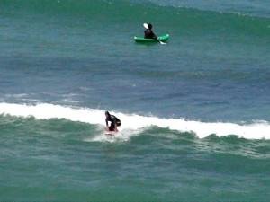
Surfers at Bastion Point
Up the hill from Tip Beach is Bastion Point where Devlin’s Inlet meets Bass Strait. There were surfers in the water, a fellow with a canoe, and people fishing from a boat. We parked high on the bluff overlooking the beach at the entrance to the inlet and could see Gabo Island in the distance.
Gabo Island
Gabo Island is approximately 16 kilometres (10 miles) north-east of Mallacoota and has one of the oldest lighthouses in Australia. In the sand on Gabo Island lies a heap of granite blocks. On one of them is the inscription: “This monument, erected by the Governments of Victoria and New South Wales, is in memory of those drowned in the wreck of the steamship SS Monumental City, May 15 1853, on Tallaberga Island, where their remains lay buried.” The steamship, built in Baltimore USA in 1850, was the first steamer to cross the Pacific Ocean under screw propulsion. She ran aground on Tallaberga Island near Gabo Island and broke in two, with the loss of 37 lives. Within months a wooden lighthouse was erected on Gabo Island and the original 20-feet high wooden tower was replaced with a red granite tower in 1862. At 47 metres (154 feet) it is the second highest in Australia and the main light has a range of 25 nautical miles. There are boat trips out to the island and joy flights over it but we decided against a visit this time. Perhaps next time.
A visit to Gypsy Point
Gipsy Point is an idyllic haven about 9 kilometres (5 miles) from Mallacoota. We drove around past Stingray Point to Bottom Lake and then on to Gipsy Point.
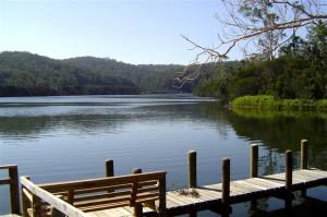
At the wharf we had a look at the tourist ferry, Gipsy Princess, operated by Rumbottles Wilderness Cruises. Unfortunately it doesn’t operate every day. Gipsy Point Lodge is quite a big holiday resort with its own jetty, right on the river, but we didn’t see one single person while we were there! And so, back to camp after a long day. Now, if John can’t find a place to fish after all of that, he’s not really trying! While we were sitting outside enjoying the coolness of the evening a friendly and very fat possum visited us but he didn’t stay around long enough for a photograph. For such a fat fellow, he certainly could move fast!
A great little coffee shop in Mallacoota
We woke the next morning to overcast skies and a visit by a few friendly kangaroos. Then the rain started. Just great! But after about 6 or 8 drops, it stopped. The clouds cleared to a spectacular day and we decided it was a day best spent on the beach. We drove into town for bait and information on the tides – yes, John was going to fish – and a quick coffee at the Croajingalong Café before heading out to the beach. Mallacoota is not a big town but it does have a few small coffee shops and cafés. We chose the Croajingolong Café mostly because of the name but we discovered that the service and the coffee are great too.
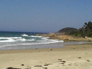
A day on Mallacoota’s Tip Beach
After our coffee we set off for Tip Beach. What has to be the most beautiful place on the Victorian Wilderness Coast, this long sandy stretch was deserted when we arrived. The water was the most startling aqua-blue colour and the sun was bright in a cloudless sky. So after setting up our sun-shelter and slapping on the sunscreen John threw in a line and I set off for the first of several walks on the beach. I walked from one end to the other, twice, before returning to the shelter.
Fishing in Mallacoota
The sun overhead was pretty fierce and even with sunscreen I could feel myself burning. John wasn’t having a whole lot of luck with the fishing but he looked like he was having fun anyway. It was so peaceful there that one could almost believe that we were the only people on the planet! Later during the day other walkers and a couple of joggers made their way along the shoreline. The sand close to the water was hard and good for walking on. I was walking again when a girl on horseback came cantering along the beach. But mostly we were the only ones there. After about 2:00 a stronger wind came up but even that wasn’t too bad. The fish weren’t biting and after about 4 hours of trying to catch something John finally decided to give up. He certainly has more patience than I do, I would have packed it in after about 20 minutes! After a long day in the sun and a lot of walking all I wanted was an early night and I fell into bed by 9:00. I was soon asleep, lulled by the sound of the surf as the waves broke gently on the sand.
Some shake, rattle ‘n’ roll
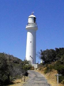
The next day we trekked to Point Hicks Lighthouse. We set off early along the Princes Highway for Cann River, 71 kilometres (44 miles) west of Mallacoota and then turned onto the Point Hicks Road for a further 45 kilometres (28 miles). The road through the Croajingalong National Park is not only unsealed but for 30 kilometres (18 miles) it is one of those shake-rattle-and-roll you sideways, corrugated ones! Believe me, everything that could rattle and shake rattled and shook! We drove over a couple of narrow one-lane bridges and through the Thurra Campground where the corrugations ended, and then the road came to an end with a locked gate. From here it was a 2¼-kilometre (1.4-mile) walk to the lighthouse station.
A long, hot walk
It was a terribly hot day with temperatures nudging 38°C (100°F) and not a cloud in the sky. Bush and trees bordered the road but these didn’t provide an awful lot of shade and we certainly appreciated what little there was! Finally the lighthouse came into view. How magnificent!
A stunning piece of Australian history
Point Hicks is a stunning piece of Australian history. This was the first view of the Australian mainland seen from Lieutenant James Cook’s Endeavour in 1770 and is named after the man who made that sighting, Lieutenant Zachary Hicks. We were able to walk down onto the rocks at the Point where there is a monument to that first sighting. The inscription on the monument reads: “Lieutenant James Cook R.N. first sighted Australia near this point which he named Point Hicks after Lieutenant Zachary Hicks who first sighted the land. April 19th (ship’s log date) April 20th (calendar date) 1770” There is also a cairn commemorating the 200thanniversary of the sighting.
The views are breathtaking
The views out to sea were astounding; such perfectly blue water under such beautiful clear skies. Breathtaking! We spent quite a bit of time out on the point, it was really quite amazing and the ocean seemed to stretch forever. Perfectly peaceful, not a boat or another person in sight; this must have been what it was like on that day in 1770. It was quite windy out there and there is no fence around the point. We weren’t concerned, it wasn’t THAT windy and I can imagine that this would not be a very safe place to be in a howling gale. But on this day it was absolutely perfect and in any case, a little wind was welcome on such a hot day.
The lighthouse
We picked our way over the rocks and explored as many nooks and crannies as we could, both of us displaying a distinct reluctance to leave this very beautiful and historic place. But we also both realised that we couldn’t stay here forever and so started to make our way back up the steps to the lighthouse. The lighthouse and the point overlook the Point Hicks Marine National Park, a protected area filled with incredible sea life and some truly spectacular sub-tidal reefs. The lighthouse, itself, offers accommodation and guided tours, and there is also a very popular campground. Bush camping only, however. Not for me, I’m afraid, I like indoor plumbing. Then we started our walk back; at least it was all downhill this time but by the time we reached the car we were more than a little hot, tired, and ready for lunch under the shade of the trees.
Dinner on Mallacoota Wharf
It was after 4:30 before we arrived back in Mallacoota and it was one of those evenings when I really didn’t feel like cooking dinner so John suggested we go out for fish and chips on the Mallacoota wharf. The wharf is a popular spot for fishing and there were a few people there with lines in the water but no one was catching anything. John said he could relate to that! There are several tourist cruise boats moored at the wharf and quite a few private boats at moorings in the inlet and finding a spot where the view of the water was unobstructed wasn’t easy. We did finally find a place with some tables and seats and nothing blocking the view and enjoyed a great fish and chip dinner with a view of the inlet, the fresh smell of the salt air and the breeze blowing in from the sea. After dinner we went for a walk around Mallacoota but the breeze had turned cool and a few clouds were rolling in so we returned to camp for an early night.
Mallacoota’s Military Museum
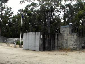
The next morning dawned overcast and cool; I didn’t mind. After the previous day’s heat and humidity and such a warm, sticky night, this was great! There is a military museum in Mallacoota and with nothing else planned for that day we decided to go and have a look. We drove out along Betka Road for a short distance and then turned off near the airport. We were quite surprised when we drove into the parking lot; it was like taking a step back in time. It really is a World War II Operations Bunker, a restored RAAF Advanced Operations Base.
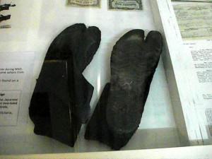
Two-toed boots!
There was a chain of these high security wartime defence bases located around the Australian coastline during World War II. This whole region was sparsely populated and was considered vulnerable to attack. In fact there is some evidence to suggest that Japanese soldiers or sailors actually came ashore here. Strange footprints were found and later identified as the unique Japanese two-toed combat boots. (I kid you not!)
Closer than we knew
The bunker at Mallacoota was important because of its close proximity to Gabo Island where the RAAF had established a radar station. The main purpose of its operation was surveillance of the area to assist in keeping our sea lanes open. Between June 1942 and June 1943 there were 13 Japanese submarines operating off the east coast of Australia. They claimed 22 allied ships, of which 12 were Australian owned, with the loss of 194 lives. Two of the ships were sunk off Gabo Island and the freighter “Iron Crown” was the only vessel torpedoed in Victorian waters. She was sunk 70 kilometres (44 miles) southwest of Gabo Island, with the loss of 38 lives. We found the history fascinating and some of the displays were very lifelike but the museum is not very big and in less than 2 hours we’d been right through it. We’d learned a few things that were not generally made public during that war and so are not mentioned in the history books and even though it all happened before either John or I were born it was rather disquieting to realise how close it really was. It makes one appreciate, just a bit more, the life we have today. Mallacoota is a not-to-be-missed outpost and the perfect base for exploring the Wilderness Coast. Walking here is a pleasure along some of the most unspoilt and beautiful bush and beach tracks in Australia in an area where you can experience nature at her most magnificent. And it is that.
2007
The information contained in this journal is derived from our personal recollections of our visit to this town or region and is correct as at the time of publication. austracks accepts no responsibility should any of this information be incorrect or misleading due to changes, improvements, or upgrades that may have occurred to places and/or attractions since our visit.